GEOG 2OC3 Lecture Notes - Lecture 7: Banff National Park, North American Cordillera, Interior Plains

23 May 2018
School
Department
Course
Professor

2OC3
Week 7
Caadia Regioal Geography Part : The West
The West
Provinces: Alberta, Saskatchewan, Manitoba
→ .% of Caadas area
→ .% of Caadas populatio
→ .% of Caadas GDP
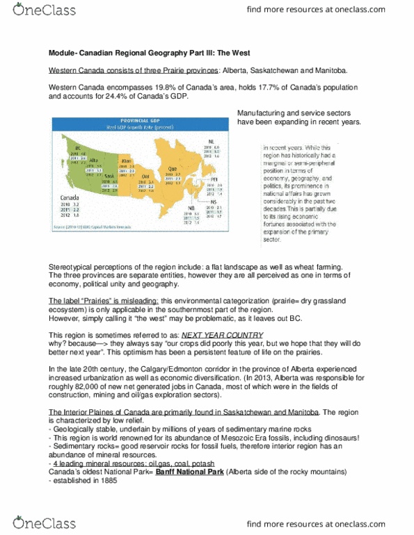
Basic Statistics
→ 2011: economic structure of west = heavily dependent on primary sector (Athabasca Tar
Sands)
→ Stereotypical Perceptions of the West: flat landscape + wheat farming
o 3 Provinces = 3 separate entities
o Prairie = misleading: only applicable to southernmost part of region
Urbanization
→ Calgary/Edmonton, Alberta = urbanization & economic diversification
o 2013: generated 82,000 new net jobs in construction, mining and oil/gas
exploration sectors
→ Interior Plains: found in Saskatchewan and Manitoba = characterized by low relief
o Geologically stable = underlain by millions of years of sedimentary marine rocks
o Striped appearance of Alberta Badlands = different depositional environments
find more resources at oneclass.com
find more resources at oneclass.com

2OC3
Week 7
→ Region Benefits = oil, gas, coal & potash
o sedimentary rocks = reservoir rocks for fossil fuels
→ Banff National Park: established in 1885, part of Canadian Cordillera
o Brings ~4 million tourists/year
Physical Landscape
→ West lies @ conjunction of 2 physiographic regions: The Canadian Shield + Interior Plains
o Landforms show some influence of glaciation, but it is not as prominent as in
southern Ontario
→ Prairie grassland ecosystem = deterrent to settling until mechanized agriculture
o Boaza Teas: up to 20 horses to break sod
→ Western Canada = continental climate (no major bodies of water)
o hot summers + cold winters
o low precipitation
o not favourable for agriculture, water deficit
→ Eastern part of region = continental interior climate
o Somewhat humid summers w/ cold winters
→ Pallisers Triangle (western part of region):
o semi-arid, frequent water deficiencies
o vegetation = sparse
o soil = brown & shallow, high lime + salt content & low organic matter
Environmental Challenges
→ 1) Drought
o Volume of water diverted from South/North Saskatchewan rivers
o Global warming = higher threat for drought
find more resources at oneclass.com
find more resources at oneclass.com
Document Summary
2011: economic structure of west = heavily dependent on primary sector (athabasca tar. Stereotypical perceptions of the west: flat landscape + wheat farming: 3 provinces = 3 separate entities, prairie = misleading: only applicable to southernmost part of region. Calgary/edmonton, alberta = urbanization & economic diversification: 2013: generated 82,000 new net jobs in construction, mining and oil/gas exploration sectors. Interior plains: found in saskatchewan and manitoba = characterized by low relief: geologically stable = underlain by millions of years of sedimentary marine rocks, striped appearance of alberta badlands = different depositional environments. Region benefits = oil, gas, coal & potash sedimentary rocks = reservoir rocks for fossil fuels. Banff national park: established in 1885, part of canadian cordillera: brings ~4 million tourists/year. West lies @ conjunction of 2 physiographic regions: the canadian shield + interior plains: landforms show some influence of glaciation, but it is not as prominent as in southern ontario.