GEOG 2OC3 Lecture Notes - Lecture 8: Boreal Forest Of Canada, Elliot Lake, Temagami

23 May 2018
School
Department
Course
Professor
2OC3
Week 8
Canadian Regional Geography Part 4: The Near North
The Near North (also called, Laurentian Highlands/Uplands)
Provinces:
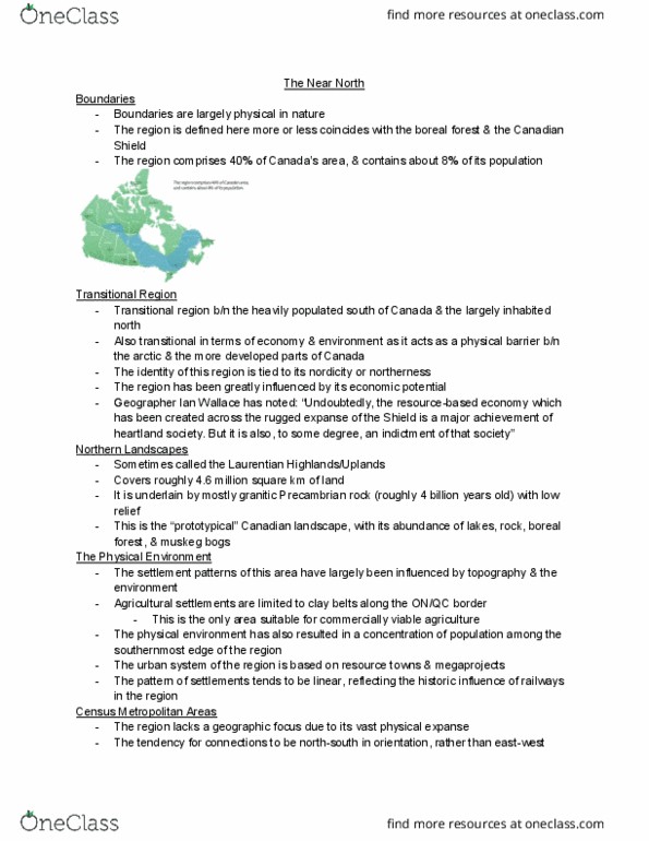
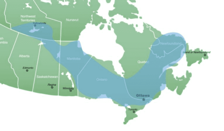
→ 40% of Caadas area
→ 8% of Caadas populatio
→ .% of Caadas GD
Basic Statistics
→ Coincides with boreal forest & Canadian Shield
→ Resource-based economy
→ Nordicity = identity
→ Stereotypical Perceptions of the West: prototypical Canadian landscape
o Granitic Precambrian rock (~4 billion years old) with low relief
o Abundance of lakes, rock, boreal forest and muskeg bogs
→ Physical Environment: resulted in concentration of population along southernmost edge of
the region
Urbanization
→ Based on resource towns & megaprojects
→ Settlement trends = linear (reflect historic influence of railways in the region)
→ Central Metropolitan Areas
o Thunder Bay
o Sudbury
o Chicoutimi-Jonquiere
find more resources at oneclass.com
find more resources at oneclass.com

2OC3
Week 8
Physical Landscape
→ Vast physical resource base including valuable resources like: forest products, minerals
and hydroelectric power potential
o Impacted by accessibility of resources
→ Impacts of human activity on environment
→ Native land claims = tension + debates
→ Proposed Economic Diversification Ideas:
o Retirement community (Elliot Lake)
o Abandoned mines for waste disposal (Timmins)
o Eco-tourism (Temagami)
→ Native Reserves
o Much of population is made up of reserves
→ Negative Externalities:
o Externality = an unpriced, unintended consequence of actions
▪ Social costs/benefits
▪ Classic example = pollution, traffic, etc.
o Environmental Movement (1960s) brought these to attention
→ The Grassy Narrows Indian Reserve
o Dryden Pulp & Paper, Dryden Chemical and later Reed International were location
in the town of Dryden
o 1962-1970: roughly 9000 kg of mercury was discharged into the river
o , kg et uaouted for
o Highly toxic to humans
o Maiu safe leel = pp
o Bioaccumulation of mercury = Minamata disease
o 1970: elevated levels were recorded → MERCURY BAN
o 1985: $16m settlement
o 2012: levels are decreasing, but symptoms are still noted even in persons born after the
mercury ban
find more resources at oneclass.com
find more resources at oneclass.com
Document Summary
Canadian regional geography part 4: the near north. Coincides with boreal forest & canadian shield. Stereotypical perceptions of the west: prototypical canadian landscape: granitic precambrian rock (~4 billion years old) with low relief, abundance of lakes, rock, boreal forest and muskeg bogs. Physical environment: resulted in concentration of population along southernmost edge of the region. Settlement trends = linear (reflect historic influence of railways in the region) Central metropolitan areas: thunder bay, sudbury, chicoutimi-jonquiere. Vast physical resource base including valuable resources like: forest products, minerals and hydroelectric power potential. Native land claims = tension + debates. Proposed economic diversification ideas: retirement community (elliot lake, abandoned mines for waste disposal (timmins, eco-tourism (temagami) Native reserves: much of population is made up of reserves. Negative externalities: externality = an unpriced, unintended consequence of actions, social costs/benefits, classic example = pollution, traffic, etc, environmental movement (1960s) brought these to attention.