EOS 101 Lecture 1: EOS Final Study Guide

5 May 2018
School
Department
Course
Professor

MASS WASTING
A. What is the difference between mass wasting, erosion, and weathering?
a. Mass wasting = Downslope movement of rock, soil, and sediment due to GRAVITY
b. Erosion = Transport of material by water, wind, or ice
c. Weathering = Loosening or chemical alteration of rocks
B. How deaths annually due to mass wasting?
a. Thousands of deaths per year
C. Mass wasting plays a role in landform development shaping the Earth’s surface.
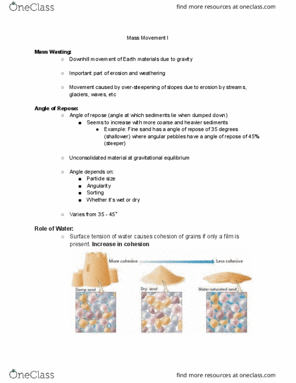
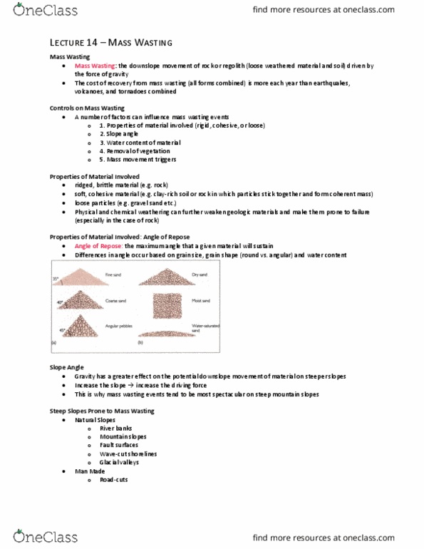
D. What is the angle of repose?
a. Angle of repose = angle at which unconsolidated material will be stable
b. Affected by grain size, shape, and moisture
i. Steep angle = large grain size, angular grain shape, and moist grains
1. Small amounts of moisture increases cohesion among grains
ii. If grains are saturated, the angle of repose will approach 0
1. Saturation reduces friction and causes sand to flow
E. What are the controls and triggers of mass wasting?
a. Water, such as heavy rainfall, reduces the angle of repose
i. Ex: La Conchita, California
b. Over-steepening of slope (slope is beyond angle of repose)
c. Vegetation removal (via human or fire)
d. Earthquakes (ex: 1964 Turnagain Heights, Alaska)
F. What are the landslide risk factors?
a. Elevation, rainfall, earthquakes, and volcanoes
G. Rate of motion for mass wasting
a. Rapid = Slump, rockfall, rockslide, debris flow (ex: lahar), earthflow
b. Slow = Creep (ex: frost heave), solufluction (ex: regions of permafrost)
H. Distinguish between the types of mass wasting:
a. Slump: rock moves as a unit along a curved surface of rupture
b. Rockslide: detached rock slip along planar surface
c. Rockfall: detached rock fall from irregular surface
d. Debris Flow: water-laden masses of soil and rock rush down mountainsides
i. Confined to canyons, may spread out as alluvial fans at the end of canyon
ii. Lahar: type of debris flow mostly consisting of ash and rock (volcanic
pyroclastic material) and water on volcanoes
e. Earthflow: grains tumble over one another in a viscous fluid (usually due to heavy rain)
f. Creep: gradual downslope movement of soil or regolith
i. Frost heave: type of creep that occurs in places with freeze and thaw cycles
1. Freezing expansion of ice grains move perpendicular to slope
2. Thaw grains drop vertically due to gravity
ii. Trees are curved
find more resources at oneclass.com
find more resources at oneclass.com

g. Solifluction: gradual downslope flow in water-saturated soil during summer in areas
with permafrost
i. Flow of soil and water in upper layer (above the permafrost)
ii. Flows in lobes if vegetation is present (see picture)
I. What happened in the Venezuela (1999) incident?
a. Debris flow after heavy rains, and the town of Caraballeda was built on an alluvial fan
b. 19,000 deaths
J. What happened in the La Conchita, California (1995 and 2005) incidents?
a. Two slumps and earthflows in both years
K. Submarine (underwater) landslides can create tsunamis.
RIVERS (RUNNING WATER)
A. The hydrosphere consists of 97% saltwater and a little less than 3% freshwater. Out of the
3% freshwater, 2.15% is in glaciers and 0.62% is groundwater and 0.03% is surface water
(rivers, lakes).
B. What are drainage basins and their divides?
a. The land area that contributes water to a particular stream or river.
b. The divide separates one basin from another – is at the highest surface elevation.
C. Example of drainage basin hierarchy.
a. Yellow River DB is in Missouri River DB, which is in Mississippi River DB.
D. Evolution of rivers with time (also can be evolution of rivers from headwaters to mouth.
a. The cross-section starts our as a V-shape and becomes wider and wider.
b. Elevated terrain floodplain whole region becomes a low plain
E. What is discharge?
a. Discharge is the volume of water passing a certain point at any given time
i. Varies with time and location
b. Q = (cross-sectional area)(velocity)
c. Q = (channel width)(channel depth)(velocity)
F. The river with the average rate of discharge measured at mouth of river
a. Amazon river, 212,400 cubic meters per second (river with highest average rate of
discharge)
b. Mississippi river, 17,300 cubic meters per second
G. What are the factors affecting water velocity?
a. Gradient (slope of the channel)
i. Greater gradient, greater velocity
b. Channel shape
i. Water velocity greatest at the farthest point from bottom and sides
find more resources at oneclass.com
find more resources at oneclass.com

ii. Drag = (cross-section area)/(wetting perimeter) the higher the ratio, the
faster the velocity
c. Channel size
i. The larger the channel, the faster the velocity
d. Channel roughness
i. The smoother the channel, the faster the velocity
H. What are the changes from headwaters to mouth?
a. Decrease in gradient and roughness
b. Increase in discharge, channel size, and flow velocity
I. What are the three types of stream transport of sediments and dissolved ions?
a. Dissolved load: ions dissolved in water (not affected by velocity)
b. Suspended load: (smaller) grains carried suspended in water
i. Size of grain that can be carried depends on water velocity
ii. Transportation – above settling velocity; deposition – below settling velocity
c. Bed load: (larger) grains roll, slide, or saltate (jump) along bottom (strong function of
velocity)
J. <>Changes in cross-sectional area through the year in 1956 along the Colorado River.
a. In Feb-May, the snow begins to melt and the sediment deposition gradually decreases
b. In June, the sediment has all been transported, so the river has high velocity and
discharge
c. In July, sediment is being deposited as water decreases and the river is back to low
velocity and discharge
K. What is a meandering stream?
a. A stream that forms loop-shaped bends in its channel
b. The maximum velocity is at the far side of the turn (also point of maximum erosion)
L. <>Types of meandering streams:
a. Point bar and cut bank = erosion of cut bank and deposition of point bar
b. Oxbow lake = an isolated meander loop
i. Occurs when water overflows at neck and finds a faster route downstream
c. Incised meander = starts out as regular meander, uplift in the plateau, and the
meander cuts into the rock
M. <>What is a floodplain and how does it develop?
a. Floodplain = wide, relatively flat area of land adjacent to a stream that floods during
times of high discharge
b. Elevated mountain terrain weathering, mass wasting, and erosion by water
widening and flattening area
N. What is a natural levee?
a. Natural levees = deposit of sediment along the river bank that form during periodic
floods in which water overflows its bank and deposits sediment
O. Mississippi Flood in 1993 caused $20 billion in damages.
find more resources at oneclass.com
find more resources at oneclass.com