EPSC 185 Lecture Notes - Lecture 5: 1978 Atlantic Hurricane Season, Maximum Sustained Wind

23 Jun 2018
School
Department
Course
Professor

Hurricane structure
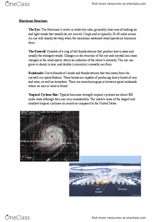
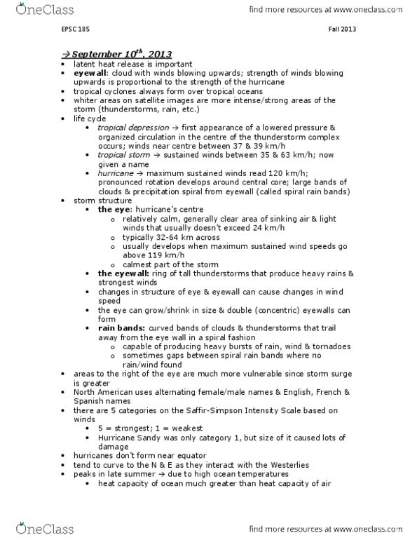
-The eye: the hurricane’s centre is a relatively calm, generally clear area sinking air and light
winds that usually do not exceed 15 mph (24 kph) and is typically 20-40 miles (32-64 km)
across. An eye will usually develop when the maximum sustained wind speeds are hurricane
force.
-The eyewall: consists of a ring of tall thunderstorms that produce heavy rains and usually the
strongest winds. Changes in the structure of the eye and eyeball can cause changes in the wind
speed, which is an indicator of the storm’s intensity. The eye can grow or shrink in size, and
double (concentric) eyeballs can from.
-Rainbands: Curved bands of clouds and thunderstorms that trail away from the eye wall in a
spiral fashion. These bands are capable of producing heavy bursts of rain and wind, as well as
tornadoes. There are sometimes gaps in between spiral rain bands where no rain or wind is
found.
-Tropical Cyclone Size: Typical hurricane strength tropical cyclones are about 300 miles (483
km) wide although they can vary considerably. The relative sizes of the largest and smallest
tropical cyclones on record as compared to the United States.
Hurricane structure:
-The location of where the land is compared with the track.
-Wind is counterclockwise so when we look at the right quadrant, that area of wind is located in
a region where the winds blowing in the south are blowing the same direction of the track of the
hurricane
-An illustration of why winds are strongest on the right side of the storm’s direction of motion in
the Northern hemisphere:
-Look at the wind speed at the right of the storm and assume that the winds surrounding the
hurricane are 100 knots; to the right of the hurricane we are adding 25 knots. So 100+25=125
knots
-But to the left we are subtracting 25b knots so 100-25=75 knots
-Depending where you are in the storm you’ll see different damage because speeds are in the
same directions as the winds to the right, but from the left we subtract the winds from the speed.
-Trajectories in a hurricane, based upon a numerical model
Hurricane hazards:
-Corresponding to wind strengths.
-Storm surge (90% of hurricane deaths are related to costal and inland storm surge). All
hurricane Irma deaths were related to storm surge on the east coast Florida-Georgia line.
-The weather + the existing tide that gets added onto the flooding.
-A storm surge is a large dome of water
-On shore winds come from the ocean and onto land.
-Danger of a storm surge increases at high tide.
-Maximum amount of storm surge tends to occur where winds blow onshore in the direction of
the storm.!
-Storm surges often break if the hit a hill (see animation with houses and hills)
-Storm surge isn’t directly related to the category of the hurricane
Hurricane hazel:
-Loss of life from hurricane hazel occurred within an hour or so because lots of people
where the main flooding was were asleep and it occurred without warning. Lost life in an
hour from drowning.
Climate change:
find more resources at oneclass.com
find more resources at oneclass.com
Document Summary
The eye: the hurricane"s centre is a relatively calm, generally clear area sinking air and light winds that usually do not exceed 15 mph (24 kph) and is typically 20-40 miles (32-64 km) across. An eye will usually develop when the maximum sustained wind speeds are hurricane force. The eyewall: consists of a ring of tall thunderstorms that produce heavy rains and usually the strongest winds. Changes in the structure of the eye and eyeball can cause changes in the wind speed, which is an indicator of the storm"s intensity. The eye can grow or shrink in size, and double (concentric) eyeballs can from. Rainbands: curved bands of clouds and thunderstorms that trail away from the eye wall in a spiral fashion. These bands are capable of producing heavy bursts of rain and wind, as well as tornadoes. There are sometimes gaps in between spiral rain bands where no rain or wind is found.