GEOG 1HB3 Lecture Notes - Lecture 2: Mercator Projection, Contour Line, International Date Line

7 May 2018
School
Department
Course
Professor

May 2, 2018- Lecture 2
Maps and Spatial Understanding
Recall:
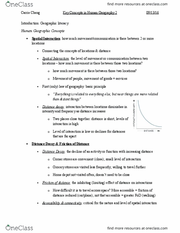
- Distance Decay: interaction between locations diminishes in intensity and frequency as
distance between them increase
o the farther something is, the less likely it is going to be visited
o the decline of an activity or function with increasing distance
▪ ex. You will only travel so far to a convenient store, but are more likely to
travel farther for something more important at a grocery store, for
example
- Friction of Distance: the inhibiting (limiting) effect of distance on interactions
- Gravity model: Iij=K * ((Pi*Pj)/ Dijx)
o K is a constant, it will always be given on an exam for this class- assume it is 1
unless otherwise stated
o If we assume that K=1, and x=2, then what level of interaction exists between
communities A&B?
- Check on avenue for gravity equation homework for fun
Map: a two-dimensional graphical representation of the world; a device use to i) communicate
information and ii) analyze (solve) spatial problems
o The locations of the orlds’ egacities
o The arket area for a retail chai
o The distribution of health, wealth, and poverty
o The diffusion of technology
- Maps are socially constructed
o Reflect the power of the people that draw them
o Read maps with a critical eye
Projection: mathematical technique for representing a 3-dimensional sphere on a 2-
dimensional map
o Three main forms of projection- each with their own advantages and limitations
▪ Hundreds of specific variations
• All have varying levels of accuracy
• Main forms of distortion are: distance, directions, and area
o Cylindrical projections: The Earth’s surface is projected oto a clider that just
touches the outside edges of the globe (usually the equator)
▪ Imagine wrapping paper around a basketball
▪ Accuracy is greatest at the Equator, and declines as you move towards
the poles
• E.g. the Mercator Projection
• Used for navigation because it has very straight and accurate
direction
find more resources at oneclass.com
find more resources at oneclass.com
Document Summary
You will only travel so far to a convenient store, but are more likely to travel farther for something more important at a grocery store, for example. Friction of distance: the inhibiting (limiting) effect of distance on interactions. Gravity model: iij=k * ((pi*pj)/ dij: k is a constant, it will always be given on an exam for this class- assume it is 1 unless otherwise stated. Check on avenue for gravity equation homework for fun. Maps are socially constructed: reflect the power of the people that draw them, read maps with a critical eye. Imagine a lamp shade: accuracy is the greatest in the mid-latitudes, azimuthal projections: the earth"s surface is projected o(cid:374)to a flat surface that touches the globe at one point only (usually the polar regions) Latitude and longitude: a system of imaginary arcs which are used to identify an absolute location for all areas of the earth.