GEOG 2OC3 Lecture Notes - Lecture 7: North American Cordillera, Clifford Sifton, Subsistence Agriculture

27 Jun 2018
School
Department
Course
Professor

Module- Canadian Regional Geography Part III: The West
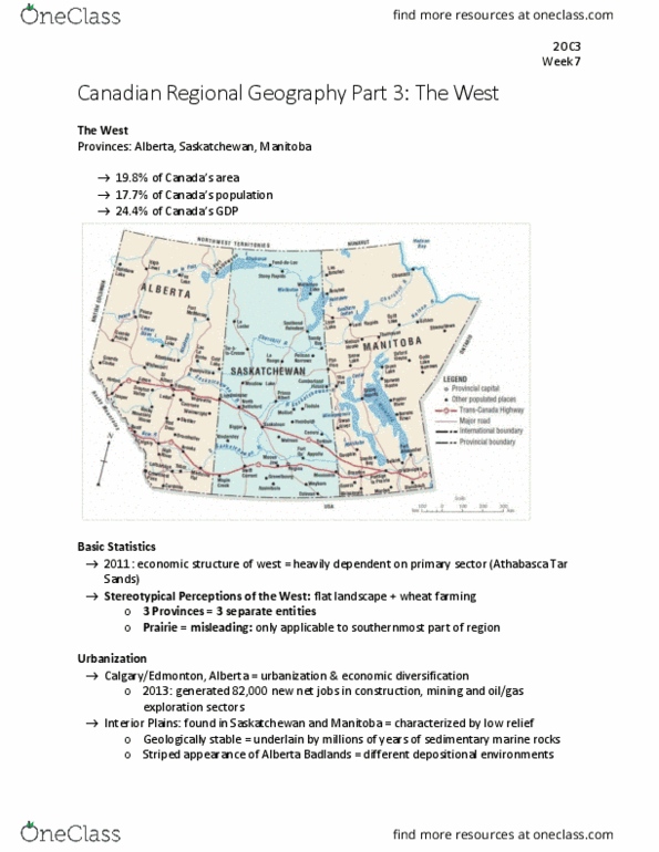
Western Canada consists of three Prairie provinces: Alberta, Saskatchewan and Manitoba.
Western Canada encompasses 19.8% of Canada’s area, holds 17.7% of Canada’s population
and accounts for 24.4% of Canada’s GDP.
Manufacturing and service sectors
have been expanding in recent years.
Stereotypical perceptions of the region include: a flat landscape as well as wheat farming.
The three provinces are separate entities, however they are all perceived as one in terms of
economy, political unity and geography.
The label “Prairies” is misleading: this environmental categorization (prairie= dry grassland
ecosystem) is only applicable in the southernmost part of the region.
However, simply calling it “the west” may be problematic, as it leaves out BC.
This region is sometimes referred to as: NEXT YEAR COUNTRY
why? because—> they always say “our crops did poorly this year, but we hope that they will do
better next year”. This optimism has been a persistent feature of life on the prairies.
In the late 20th century, the Calgary/Edmonton corridor in the province of Alberta experienced
increased urbanization as well as economic diversification. (In 2013, Alberta was responsible for
roughly 82,000 of new net generated jobs in Canada, most of which were in the fields of
construction, mining and oil/gas exploration sectors).
The Interior Plaines of Canada are primarily found in Saskatchewan and Manitoba. The region
is characterized by low relief.
- Geologically stable, underlain by millions of years of sedimentary marine rocks
- This region is world renowned for its abundance of Mesozoic Era fossils, including dinosaurs!
- Sedimentary rocks= good reservoir rocks for fossil fuels, therefore interior region has an
abundance of mineral resources.
- 4 leading mineral resources: oil,gas, coal, potash
Canada’s oldest National Park= Banff National Park (Alberta side of the rocky mountains)
- established in 1885
find more resources at oneclass.com
find more resources at oneclass.com
Document Summary
Module- canadian regional geography part iii: the west. Western canada consists of three prairie provinces: alberta, saskatchewan and manitoba. Western canada encompasses 19. 8% of canada"s area, holds 17. 7% of canada"s population and accounts for 24. 4% of canada"s gdp. Manufacturing and service sectors have been expanding in recent years. Stereotypical perceptions of the region include: a flat landscape as well as wheat farming. The three provinces are separate entities, however they are all perceived as one in terms of economy, political unity and geography. The label prairies is misleading: this environmental categorization (prairie= dry grassland ecosystem) is only applicable in the southernmost part of the region. However, simply calling it the west may be problematic, as it leaves out bc. This region is sometimes referred to as: next year country why? because > they always say our crops did poorly this year, but we hope that they will do better next year .