GEOG 213 Lecture 1: NOTES

12 Jun 2018
School
Department
Course
Professor
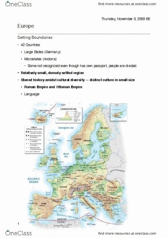
Man-made theory of a continent
○
Ultimately it is part of the Eurasian continent but manmade definitions put physical
boundaries like the Ural Mountains and Bosporus.
○
Maritime climate in much of France, Britain, Spain, Ireland
○
Mediterranean climate in southern France, Spain, Italy, Greece, Croatia
○
Continental climate in Eastern Europe, Austria, Germany, Poland, Russia
○
Alpine variable climate around alps, Pyrenees, Massif Central
○
Polar climate in Iceland, northern Sweden, Norway, Russia
○
CLIMATE ZONES
•
Various stores of various resources from the wide range of climate and natural
environments
○
RESOURCES
•
Warm ocean currents along the North Atlantic coasts of Ireland, UK, and
Scandinavian countries
▪
Prevailing westerlies blows warm moist air north
▪
These currents keep the Baltic Sea warmer than most bodies of water at that
latitude
▪
This warming effect makes all of Europe warmer, not just the north
▪
Why is it so warm considering latitude?
○
CLIMATE
•
1. Central Uplands - Germany, France, Poland
•
2. Alpine Mountains - Switzerland, Austria, Italy, Greece, Spain
•
3. Western Uplands - Scandinavia, Spain, UK
•
4. Northern European Lowland - Eastern Europe, France, UK,
•
4 physiographic units:
▪
Physiography: total physical geography
○
LANDFORMS
•
Similar to North American western plain
○
Formed from bedrock of ancient seas
○
Wars, migration, etc.
▪
One of the world's greatest avenue of human contact, positive and negative
○
Really, a number of connected plain regions including delta regions, Paris basin,
Baltic plain, etc.
○
The European hills - Massif Central, Hercynian hills (Black Forest), Bohemian hills
○
Subdivided by numerous river valleys and basins
○
EUROPEAN PLAIN
•
Collision of Indo-Australian Plate with Eurasian plate to form Himalayas
○
Mountain ranges like the Alps, Apennine, Pyrenees, and Pindos formed by collision
○
PLATE BOUNDARIES
•
PHYSICAL ENVIRONMENT OF EUROPE
EUROPE
Wednesday, January 31, 2018
3:33 PM
Geography 213 Page 1
Mountain ranges like the Alps, Apennine, Pyrenees, and Pindos formed by collision
between African and Eurasian Plates
○
Eurasian plates form volcanic ranges and arcs in the pacific region where Eurasian
plate and pacific plate collide
○
Mostly deciduous forest
○
Scandinavian countries tend towards a Boreal Forest
○
FOREST
•
Correlation between population and land around rivers with soil good for farming
○
POPULATION DISTRIBUTION
•
Primary geomorphologic mechanism
○
Primary sediment transportation
○
Very hospitable for crops
▪
Create fertile soil and microclimates around river valleys
○
Major transportation mechanism - less so now
○
Water source
○
Now the water is some of the cleanest rivers in the world
▪
When rivers flood it damages crop land because of the residual effects of the
polluted river beds
▪
Used to get very polluted because of industrial revolution and urbanization
○
RIVERs
•
Links to Africa and Asia
○
Maximum efficiency for global contact
○
LOCATIONAL ADVANTAGE
•
First major historical European society
○
Bunch of joined city-states
○
ANCIENT GREECE
•
Eventually defeats enemies and becomes larger than Greek Empire
○
Grekification of Rome
▪
Envelopes Greece and adopts many of the Greek practice, religion, government, etc.
○
Western empire overtaken by Germans
▪
Eastern overtaken by Ottoman - lasted much longer than the West
▪
Roman Empire split into Eastern and Western
○
IMPERIAL ROME
•
Worked for feudal lords who provided them with land and demanded crops as
rent payment
▪
Peasants were indentured - unable to leave land or change positions - dad was
a farmer, son was a farmer. Dad was a blacksmith, son was a blacksmith, etc.
▪
Vast majority of population peasants
○
Bourgeoise middle class of merchants arises
○
Social order was based on custom and tradition
○
FEUDALISM
•
HISTOICAL EUROPE
Geography 213 Page 2
Peasant families would always work for the same family of lords
▪
Social order was based on custom and tradition
○
Diet lacked nutritional value
○
Life expectancy was less than t50
○
Inhospitable climate - famine every few years
○
From 950-1250 - 0.4% pop growth/year
○
Cities were few and far between and very small populations
▪
Very small urban population
○
In the cities, guilds of skilled craftsmen lived and worked
○
Rebirth
○
Revival of science, new discoveries, culture
○
RENAISSANCE
•
Exploration led the way to competition driven by capitalism and colonialism
○
Social revolution and rise of merchant class challenges status quo
○
Rapid urbanization
○
Population growth and urbanization increased opportunities for farmers
▪
Land ownership practice changed
▪
Merchants with crops from the Americas drew farmers into the economy
▪
Growth of Agricultural Industry
○
MERCANTILISM
•
1348 - bubonic plague carried by rats kills one third of European population
○
Resulted in labour scarcity but lots of land
○
Weakened the landowners and made peasants less weak
○
Serfs could move away from their lords with less fear of being recaptured
○
THE BLACK PLAGUE
•
Industrial transformation of agrarian Europe
○
Significant growth and innovation starting in Britain and spreading into the
rest of Europe
▪
Creation of steam engine
▪
Coal mines discovered
▪
Industrialized society
▪
Britain at the center of the revolution
○
Industrial cities became the backbone of Europe’s population
▪
East-west industrial axis (Britain, France, Italy, Germany, etc.)
▪
Huge urbanization
○
THE INDUSTRIAL REVOLUTION
•
Same size as United States
○
Consists of many independent states
○
Some states are homogenous nation states while others are a heterogeneous mix of
different ethnicities, religions, languages, and cultures
○
Separatism, nationalism and external influences are strong forces in Europe
○
FRAGMENTATION OF EUROPE
•
Geography 213 Page 3
Document Summary
Ultimately it is part of the eurasian continent but manmade definitions put physical boundaries like the ural mountains and bosporus. Maritime climate in much of france, britain, spain, ireland. Mediterranean climate in southern france, spain, italy, greece, croatia. Continental climate in eastern europe, austria, germany, poland, russia. Alpine variable climate around alps, pyrenees, massif central. Polar climate in iceland, northern sweden, norway, russia. Various stores of various resources from the wide range of climate and natural environments. Warm ocean currents along the north atlantic coasts of ireland, uk, and. These currents keep the baltic sea warmer than most bodies of water at that latitude. This warming effect makes all of europe warmer, not just the north. 4 physiographic units: central uplands - germany, france, poland, 2. Alpine mountains - switzerland, austria, italy, greece, spain: 3. Western uplands - scandinavia, spain, uk: 4. Northern european lowland - eastern europe, france, uk,