BIOL150 Lecture Notes - Lecture 3: Hudson Bay Lowlands, Carolinian Forest, Ecodistrict

17 Oct 2013
School
Department
Course
Professor
Document Summary
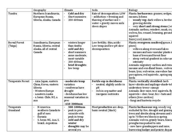
Chile and new zealand: moderate, moderate variation, variable with seasons, drops below freezing (plants dormant) Sets of ecosites, land form, surface material, vegetation, old growth, road access planning, wood supply. Topography, substrate, hydrology, vegetation, species at risk management, environmental assessments (crown. Range and pattern of climate variables, with in uence on vegetative type and soil formation. Substrate and vegetation types, may occur in multiple ecosites or ecodistricts, mapping areas of special management concern, evaluation natural heritage, Climate long winters, short summers in uence of permafrost. Land use: 22. 7% forest cover includes ontario"s largest protected area: polar bear. Provincial park: diamond mining, 74. 9% forested, boreal: 73. 7% forest, mainly, great lakes: some agriculture land conifers here, 90% of ontario"s population lives, 14. 8% forested, 59. 3% agriculture. Why conifers dominant in the north: early photosynthesis because there is no, less n necessary because no new leaves need for leaf out each summer.