EESB18H3 Chapter : Study Guide For EESA05, Chapter 9

19 Jul 2010
School
Department
Course
Professor


!
1!
Chapter 9: Coastal Hazards
9.1 Introduction to Coastal Processes
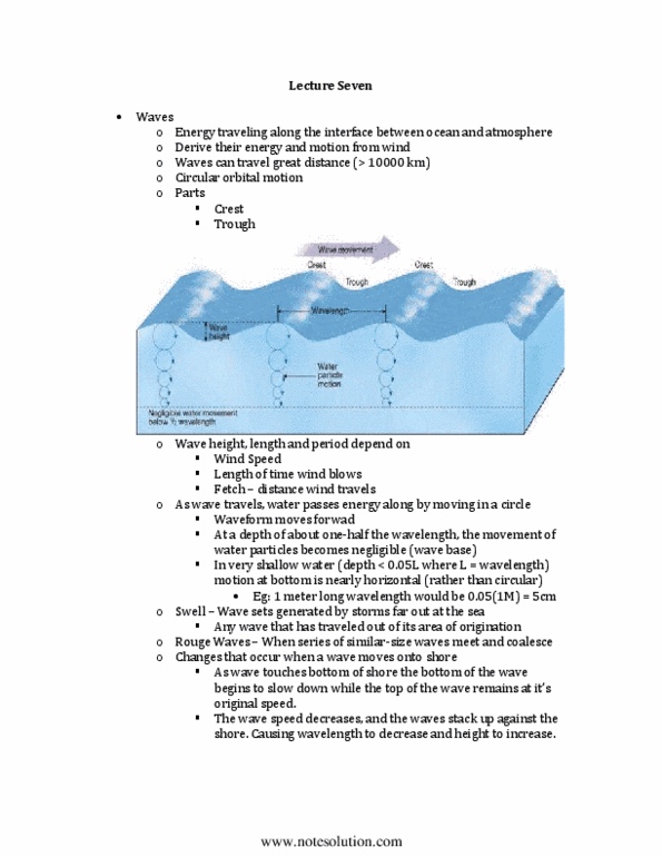
Waves
" waves are generated by wind; wind blowing over the ocean or a lake transfers some of its energy to the water,
producing waves
" waves travel through the water and eventually expend their energy at the shoreline
" they have a range of sizes and shapes – the size of it depends on a combo of the following:
o velocity of the wind; the stronger the wind, the larger the waves
o duration of the wind; those tat last longer have more time to impart energy to the water, thereby producing larger
waves
o distance of the wind blows across the water, referred to as the fetch; longer fetch allows larger waves to form,
thus waves in the ocean are generally larger than those in a lake
" as waves move away from their source, they become organized into groups, or sets, of similar size and shape; sets
of waves may travel long distances across the ocean and arrive at distant shores with little loss of energy
" sets with different characteristics arrive at coastlines at different times
" alteration of small and large sets allow surfers to wait and take advantage of the sets of larger waves that they know
will eventually arrive
" interactions among different sets from different sources produce a regular pattern, or surf beat
" unusual large rogue waves arrive at shore with disastrous results
" waves moving across deep water have a similar basic shape or wave form
" 3 parameters describe the size and movement of a wave:
o wave height (H)- difference in height between the trough and crest of a wave
o wavelength (L)- distance between successive wave crests
o wave period (P)- time in seconds for successive waves to pass a reference point
! reference point used to determine wave period can be a pier or another object anchored to the seafloor
" one can understand how waves transmit energy thru the water by studying the motion of an object on the water
surface and one below the surface
o when a wave moves thru the area, an object 20 m below the surface moves up, forward, down and back in a
circular orbit, always returning to the same place
o an object nearer the water surface also moves in circles but the circles are large
" shape of orbital motions changes as waves enter shallow water
o at depth of less than ! their wavelength the waves begin to feel the bottom, causing the circular motions to
become ellipses
o in very shallow water (depth"0.05L), the motion at the bottom may be horizontal with only a small vertical
component
" wave sets generated by storms far out at sea are called swell
o wave height, period and velocity of swell can be predicted by using equations based on the fetch, wind velocity
and length of time the wind blows over the water
! by knowing the velocity and height of the waves generated by a distant storm, we can estimate when the waves
will strike the shore and how erosive they will be
" as waves approach the coast, they become unstable and break
o wavelength and velocity decrease and wave height increases; only wave period remains constant
o waves also change shape from rounded crests and troughs found in deep water to peaked crests with relative flat
troughs in shallow water
" as waves approach their breaking point in shallow water, their height may increase to twice that in deep water
" the waves collapse, or break, toward the beach because the wave crests keeps moving fwd while the lower part of
the wave slows down
" waves release a lot of energy as they rush ashore; the energy is ~ proportional to the square of wave height—waves
5 m high expend ~ 25 times the energy of waves 1 m high
Variation along a Coastline
" wave heights along a coat may increase or decrease as waves approach the shore
o variations caused by irregularities in near-shore bathymetry and the shape of the coastline
www.notesolution.com

!
2!
o irregular coastlines commonly have small rocky peninsulas known as headlands. Shoreline between headlands
may be relatively straight or somewhat curved. A long wave approaching the coast will first slow down in the
shallow water off the headland. The slowdown causes the wave to bend, or refract, around the headland and thus
to become more parallel to the shoreline
Effects of Wave Refraction
" refraction causes convergence of wave normals at the headland and divergence along the shoreline way from the
headland
" where wave normals converge, the height and energy of the wave increases
" largest waves along a shoreline are generally found along rocky headlands
" long term effect of greater energy expenditure on protruding areas, such as headlands, is that the shoreline tends to
become straightened
Breaking waves
" waves also differ in how they break along a shore
" breaking waves may plunge or surge, or they may gently spill onto the shore, depending on local conditions
" plunging breakers form steep beaches and can be very erosive
" spilling breakers commonly develop a wide, gently sloping, sandy beaches and are less erosive than plunging
breakers
" in estuaries subject to large tides, inflowing tidal waters may be slowed by out-flowing river water to produce tidal
bores
" tidal bores have very steep fronts, and surge fwd like broken waves
" breakers along a particular reach of the coast can also change seasonally and with changes in water slope and
topography
Beach Form and Processes
" a beach consists of loose material, such as sand or gravel, that has accumulated by wave action at the shoreline
" wave energy and beach shape are other factors affecting beach material
" most steep, high energy beaches are gravel
" gently sloping, lower-energy beaches consist of sand
Beach Onshore
" landward boundary of a beach can be a cliff, called sea cliff, along seashore and a bluff along a lakeshore, one or
more sand dunes or terrestrial vegetation
" sea cliffs and lakeside bluffs are erosional landforms produced by waves, currents and landslides
" coastal and sand dunes form by deposition of windblown beach sand
" onshore portion of beach can be divided into 2 zones that are parallel the shoreline
o flat or slope gently landward called berm—located at the backshore of a beach and consists of sand deposited by
waves as they rush up and expend the last of their energy
! beaches can have more than 1 berm or none at all
o another slopes seaward of the berm -- called beachface
! beach slope steepens toward the water
! it lies in part within the swash zone, which experiences repeated up-rush and backwash of waves
! swash zone shifts seaward or landward because of changes in water level resulting from storms or tides
Beach Offshore
" surf zone and breaker zone lie directly offshore of the swash zone
" surf zone is located just seaward of the swash zone and is the place where waves move turbulently toward the
shore after they break
" breaker zone: incoming waves peak and breaks
" low ridge consisting of sand or gravel, called a longshore bar, occurs on the seafloor or lake floor in the breaker
zone
" longshore trough may form by wave and current action landward of longshore bar
" both the bar and trough are elongate parallel to the crests of the breaking waves
" wide and gently sloping beaches may have several lines of breakers and longshore bars
Sand Transport
" storms erode sand from beach and redeposit it either offshore or landward in dunes
" sand also carried parallel to the shore in the swash and surf zones by a process called littoral transport
www.notesolution.com

!
3!
o LT consists of 2 processes:
! Beach drift: repeated shoreward and seaward movement of sand in the swash zone produces a sinuous or zigzag
transport path; the shoreward component of movement is an angle to the shoreline, whereas the seaward
component is nearly perpendicular to the shoreline
! Longshore drift is the transport of sediment by currents that flow parallel to the shoreline, called longshore
currents
o Both types of drift occur where waves strike the coast at an angle other than 90 degrees
" Updrift and downdrift refer to direction that sediment is moving or accumulating relative to the direction of the
incoming waves
" LT is limited or does not occur on the steep, rocky shorelines that form much of Canadian coast
Landforms Produced by Littoral Drift
" spits, barrier islands and tombolos formed by wave, currents and longshore drift
" spits: long, narrow, low-lying ridge of sand or gravel that extends parallel to the shore from a point of land on the
coast, commonly a head land or a cliff or bluff that is being eroded by waves
o spits taper to a point, but their foundations continue below water level farther in the direction of longshore drift
" tombolos are spits that are attached to the coast at both ends – they enclose brackish or freshwater ponds or lakes
" barrier islands are wider than spits and extend for long distances along sea coasts
o isolate bays and coastal waterways from the open ocean
Rip Currents
" rip currents carry large amounts of water directly away from shore
" they develop when series of waves pile up water between the longshore bar and the swash zone—this water moves
seaward in narrow zones, commonly m to dozens of m wide
" they can extend seaward perpendicular to the shoreline for distances of hundreds of ms
" widen and dissipate once they have passed the line of breaking waves
" they may erode a channel thru a longshore bar and thus become fixed in position for hours or days
9.2 Tropical Cyclones
" tropical cyclone is a general term applied to large cells of moisture-laden air that rotate around an area of low
pressure
" form a warm tropical or subtropical oceans and have a variety of names depending on their intensity and location
o low intensity are called tropical depression and tropical storms
o high intensity are called typhoons, tropical cyclones or cyclonic storms—in Atlantic and NE pacific ocean are
called hurricanes
Hurricane Formation
" part of the storm must have sustained winds of at least 119 km/h
" require a lot of energy, which they acquire by evaporating tropical or subtropical ocean water
" form only in oceans that are warmer than 26.5 C
" most start out as tropical disturbances, which are large areas of unsettled weather with organized thunderstorms
that persist for more than 24 hrs
o TD is associated with an elongated area of low pressure called trough
o Air in disturbance is weakly rotating because of the Coriolis effect
" Low pressure cell forms when winds increase and rotate around the area of disturbed weather
" Low pressure cells are areas of lower than normal atms pressure that are typically associated with cloudy and rainy
weather
" At this point, the disturbance is called tropical depression
" Warm moist air is drawn into the depression and begins to spin faster, much as spinning ice skaters increase their
rate of rotation by bringing in their arms
" Once maximum sustained winds speed reach 63 km/h, the depression is upgraded to a tropical storm and receives
are name. it may increase in intensity to become a hurricane
" Most tropical storms, never become hurricanes
Hurricane Characteristics
" hurricanes require a supply of warm water to sustain them
" hurricane winds blow in a large spiral surrounding a calm central area known as the eye
" in northern hemisphere, winds circulate in a counterclockwise direction because of the Coriolis effect
www.notesolution.com
Document Summary
waves are generated by wind; wind blowing over the ocean or a lake transfers some of its energy to the water, producing waves. waves moving across deep water have a similar basic shape or wave form. waves release a lot of energy as they rush ashore; the energy is ~ proportional to the square of wave height waves. 5 m high expend ~ 25 times the energy of waves 1 m high. wave heights along a coat may increase or decrease as waves approach the shore: variations caused by irregularities in near-shore bathymetry and the shape of the coastline. 1 www. notesolution. com irregular coastlines commonly have small rocky peninsulas known as headlands. Shoreline between headlands may be relatively straight or somewhat curved. A long wave approaching the coast will first slow down in the shallow water off the headland.