EESB18H3 Chapter 7: Study Guide For EESA05, Chapter 7

19 Jul 2010
School
Department
Course
Professor

!
"!
Chapter 7: River Flooding
# permeability of clay is low; rain and floodwater do not seep into ground as they would in other settings—
instead water accumulates on the land surface
# isostatic depression= centre of loading
7.1 An introduction to Rivers
# water evaporates from Earth’s surface (from oceans); it exists as a gas in the atms; it precipitates on
oceans and lands.
# Some of the water that falls on land as rain or snow infiltrates into the ground or returns to the atms thru
evaporation and transpiration by plants.
# Much of the water that falls on land, returns to the ocean via surface flow along paths determined by local
topography
# Surface flow, referred to as runoff, finds it way to small streams, which are tributaries of larger streams or
rivers
# Stream: any body of water that flows in a channel
# The region drained by a single stream is called drainage basin, watershed, river basin or catchment
# One characteristic of a river is the slope of the surface over which it flows, or its gradient. The gradient of
the river is determined by calculating the drop in elevation of the channel over some horizontal distance
and is commonly expressed in m/km or as dimensionless number (elevation drop in m divided by
horizontal distance in m)
# Gradient of a river is greatest in its headwaters, decreases downstream, and is lowest at the river mouth,
which is its base level
# Base level of a river is the lowest elevation to which it may erode. Generally, this elevation is at or near
sea level, although a river may have a temporary base level, such as a lake
# A graph showing downstream changes in a river’s elevation is called a longitudinal profile
# The valley of a river is steeper-sided and narrower in its headwaters than near the river mouth, where a
wide floodplain may be present
# At higher elevations, the steeper gradient of the river facilitates erosion and downstream transfer of
sediment
# Many valleys in glaciated mountains have a U-shaped cross-sectional profile—the eq’m form that results
from lengthy erosion by valley glaciers
# Valleys in non-glaciated mt landscapes have V shaped cross-section produced by fluvial erosion and
mass wasting
Material Transported by Rivers
# material that it transport is called total load (TL), and consists of bed load, suspended load, and dissolved
load
# bed load comprises particles of sand and gravel that slide, roll and bounce along the channel bottom in
rapidly moving water—constitutes less than 10% of TL
# suspended load comprises mainly silt and clay particles carried in suspension above the riverbed—90%
of TL; gives muddy appearance
# dissolved load comprises electrically charged atoms or molecules, called ions, that are carried in solution
in the water—most derived from chemical weathering of rock and sediment in the drainage basin
o ions in discharging underground springs, sewage and chemical effluence can be a significant part of the
dissolved load of some rivers
River Velocity, Discharge, Erosion and Sediment Deposition
# velocity of water changes along the length of a river, affecting channel characteristics and both erosion
and sediment deposition
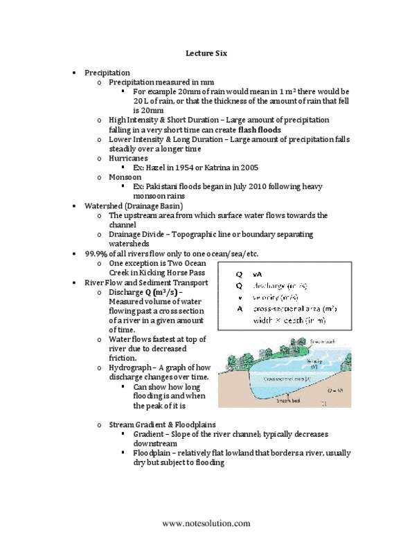
# hydrologists combine measurements of flow velocity and cross sectional area of the flow (A) to
determine discharge (Q), a more useful indicator of stream flow than velocity alone
www.notesolution.com

!
$!
# discharge is the volume of water moving through a cross-section of a river per unit of time and is reported
in units of cubic meters/sec—it is calculated by multiplying the cross-sectional area of the water in the
channel by the flow velocity
# flow velocity and cross-sectional area are related
o if cross sectional area decreases, the velocity of water must increase for discharge to remain constant
# the gradient of a river decreases where it flows from mts onto a plain or into an ocean or lake; in these
places, river builds a fan-shaped body of sediment on land referred to as an alluvial fan, or a triangular or
irregular shaped deposit in water called a delta
# flood hazard on alluvial fans and deltas is different from that on the floodplain of a river
# at the head, or apex of an alluvial fan or delta, the river commonly enters a system of distributary
channels that carry parts of the discharge to different parts of the fan or delta. These channels may change
position rapidly during a single flood or from one flood to the next, creating hazard that is difficult to
predict
Channel Patterns and Floodplain formation
# most features of rivers result from the interaction of flowing water and moving sediment
# three common channel patterns are:
(1) braided: with a large number of intersecting active channels; these have unvegetated sand and gravel bars
that divide and reunite the main channel, especially during low flow; these tend to be wide and shallow
compared with meandering channels. A river is likely to have a braided pattern if it has an abundant
coarse bed load and large diurnal variations in discharge. These conditions are found in areas where the
land is rising because of tectonic processes and where rivers receive abundant water and sediment from
glaciers
(2) anastomosing: with two or more channels and intervening stable islands or bars
(3) meandering: with a single channel shaped like a snake; meanders migrate back and forth across the
floodplain over years or centuries; water moves faster along the outside of a meander bend than along the
inside. The fast-moving water erodes the riverbank on outside of the bend to form a steep slope known
as a cutbank. In contrast, slower water on the inside of a meander bends deposits sand and sometimes
gravels to form a pointbar.
# erosion of the cutbank and deposition on the point bar cause the meander bend to migrate laterally over
time
# adjacent meander bends migrate in opposite directions and, overtime, the path of the river between the
two meanders bend lengthens because of the increasing lateral separation of the bends—this process
creates an unstable situation
# eventually, during a flood, the river avulses—it leaves channel directly downstream of the first bend and
cuts a new channel along the much shorter route to the upstream end of the 2nd bend
# during avulsion, the river abandons a looping section of the old channel, which is left as a meander cutoff
# lakes within the old abandoned channel are termed oxbow lakes—this process is important in
constructing and maintaining some floodplains
# floodplains are built at times of overbank flow, when rising waters spill over the riverbank and onto the
floodplain. The escaping waters deposit fine sand, silt and clay, thus building up the floodplain
# much of the sediment transported by rivers is temporarily stored in a variety of types of bars within the
channel
# meandering and anastomosing channels commonly contain a series of regularly spaced pools and riffles
o pools are deep areas produced by scour at high flow
o riffles are shallow areas formed by sediment eroded from the pools
# at low flow, pools contain relatively deep, slow-moving water and riffles have shallow, fast-moving
water
o such changes in water depth and velocity along a stream create different habitats for organisms,
increasing the diversity of aquatic life
www.notesolution.com