EVSC10001 Lecture Notes - Lecture 29: Intertidal Zone, Littoral Zone, Desiccation

10 Jun 2018
School
Department
Course
Professor

Coastline: zone of transition b/w terrestrial and marine environments
Determined by
Sea level
-
Underlying tectonics
-
Contemporary processes
-
-
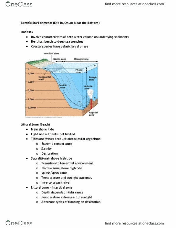
Littoral zone: close to shore - from high water mark (rarely inundated) to
shoreline areas that are permanently submerged
Includes the intertidal zone (b/w high tide and low tide)
Intertidal zone habitat pressures
Desiccation - risk of drying out
Exposure to air at low tide + higher temps
□
§
High and variable salinity
Increased temp variation and salinity variation, increased
time exposed to air, decreased competition, increased
sunlight (AT HIGH TIDE)
□
§
-
-
Coastal zone and energy
Energy gradient across coastal zone determined by processes acting with
each zone
Change in grain size (fine-coarse)
-
Depositional features
-
-
Berm: flat strip of land, raised bank, or terrace - embankment
-
WAVES
Important in influencing coastal morphology
-
Generated by wind blowing on the ocean's surface
-
Influenced by
Wind seed
-
Wind duration
-
Fetch distance
Fetch: distance of water that the wind moves across in a
constant direction to generate waves
§
-
-
Southern Ocean has large fetch distance - high-energy waves year round
Strong WESTERLY WINDS + Southern Ocean lows moving up from
Antarctica
-
SOUTH: highest waves and windspeed
-
-
Wave shoaling
Shoaling: Waves propagate into shallower water -> they deform
Height and steepness increase while wave speed decreases
-
Crest travels faster than base = critical steepness
-
Eventually leads to wave BREAKING in shallow water
-
-
Deeper water waves not affected by bottom
-
Intermediate depths
D < 1/2 L = shoaling
§
Elliptical orbits
§
Waves feel bottom
§
-
SHALLOW WATER: Closer to shore -> waves feel bottom + steepen
Interaction with bed (friction)
§
Sediment transport + stirring
§
-
Swash-Backwash
Swash: movement of water up beach
-
Backwash: movement of water down beach (gravity)
-
Waves approach shore at oblique angle (15-45 degrees)
-
Longshore current created
-
Sediment zig zags up and down the beach in direction of wave approach
with swash-backwash drift
-
What controls coastal morphology?
Energy for transport/erosion1.
Sediment supply2.
Contemporary processes -waves vs. tides 3.
Geology (tectonics) - active vs. passive margin4.
Sea levels -rise = transgression ; fall = regression 5.
Narrow swash zone - steep beach profile
-
Pure gravel (>1mm) Usually found where there is rock sources from rivers
and cliffs nearby - weathering and erosion
-
Relative tidal range (RTR) quantifies the dominance of waves to tides along
any coastline
Low RTR < 3 -> wave dominance
-
RTR = spring tidal range (m) / breaking wave height (m)
-
Microtidal coasts (wave-dominated)
Tidal range < 2m
-
Mostly waves
-
Sedimentary environment (coarser swash -> beach seds)
-
Sediment supply = large
-
Features: lagoon, barrier spit, bay barrier (erosion below accumulation
when no sediment)
-
Rocky Coasts (wave dominated)
Erosion concentrated in fractures, bedding planes, and weaker rock -
cuts back landward over time
-
Weathering/erosion
-
Waves + tides and subaerial weathering (eg. Abrasion - cliffs retreat ->
form abrasion platform (wavecut bench))
Wavecut notch: undercliffing of cliff
§
-
Hydraulic action (waves hammering energy), abrasion, corrosion
(chemical organisms interact with rocks)
-
Refracted waves focus energy to sides of headland
Erosional attack from both sides -> sea arch forms
Collapse of arch -> remnant sea stacks□
§
-
Mesotidal Coasts (mixed energy)
Key features: barrier islands with multiple inlets, larger tidal range on beach,
lower wave energy, tidal DELTAS
-
Tidal range 2-4m
-
Macrotidal coasts (tide-dominated)
Tidal range > 4m
-
Very low waves
-
Finer sediment (muds)
-
Tidal flats
-
Tidal creeks
-
Funnel shaped estuaries
-
Low-gradient beach
-
Meandering channels
-
Tidal flats -> mangroves
-
Coastal change
Sea level rise = transgression ; fall = regression
130 thousand years ago transgression - ice sheet melted
-
20 thousand regression
-
-
Global mean sea level (avg. MSP)
PLATE TECTONICS
-
GLOBAL GLACIATIONS (EUSTASY)
-
-
Tectonic processes
-
Emergent coast: falling SL1.
Exposed wave-cut bench - land surface rises
-
Submergent coast: rising SL2.
Drowned valley, headland
-
How can there be 2 wave-cut notches?
Raising/lowering of sea level
-
Tectonic uplift
-
-
Extreme Wave Events
Washover fans
-
Storms, hurricanes, tsunamis
High energy, transport of boulders
-
-
Storm deposit
Coarse gravel over existing soil
-
-
Storm ridges
-
Coastlines
Thursday, 7 June 2018
3:56 pm

Coastline: zone of transition b/w terrestrial and marine environments
Determined by
Sea level
-
Underlying tectonics
-
Contemporary processes
-
-
Littoral zone: close to shore - from high water mark (rarely inundated) to
shoreline areas that are permanently submerged
Includes the intertidal zone (b/w high tide and low tide)
Intertidal zone habitat pressures
Desiccation - risk of drying out
Exposure to air at low tide + higher temps □
§
High and variable salinity
Increased temp variation and salinity variation, increased
time exposed to air, decreased competition, increased
sunlight (AT HIGH TIDE)
□
§
-
-
Coastal zone and energy
Energy gradient across coastal zone determined by processes acting with
each zone
Change in grain size (fine-coarse)
-
Depositional features
-
-
Berm: flat strip of land, raised bank, or terrace - embankment
-
WAVES
Important in influencing coastal morphology
-
Generated by wind blowing on the ocean's surface
-
Influenced by
Wind seed
-
Wind duration
-
Fetch distance
Fetch: distance of water that the wind moves across in a
constant direction to generate waves
§
-
-
Southern Ocean has large fetch distance - high-energy waves year round
Strong WESTERLY WINDS + Southern Ocean lows moving up from
Antarctica
-
SOUTH: highest waves and windspeed
-
-
Wave shoaling
Shoaling: Waves propagate into shallower water -> they deform
Height and steepness increase while wave speed decreases
-
Crest travels faster than base = critical steepness
-
Eventually leads to wave BREAKING in shallow water
-
-
Deeper water waves not affected by bottom
-
Intermediate depths
D < 1/2 L = shoaling
§
Elliptical orbits
§
Waves feel bottom
§
-
SHALLOW WATER: Closer to shore -> waves feel bottom + steepen
Interaction with bed (friction)
§
Sediment transport + stirring
§
-
Swash-Backwash
Swash: movement of water up beach
-
Backwash: movement of water down beach (gravity)
-
Waves approach shore at oblique angle (15-45 degrees)
-
Longshore current created
-
Sediment zig zags up and down the beach in direction of wave approach
with swash-backwash drift
-
What controls coastal morphology?
Energy for transport/erosion1.
Sediment supply2.
Contemporary processes -waves vs. tides 3.
Geology (tectonics) - active vs. passive margin4.
Sea levels -rise = transgression ; fall = regression 5.
Narrow swash zone - steep beach profile
-
Pure gravel (>1mm) Usually found where there is rock sources from rivers
and cliffs nearby - weathering and erosion
-
Relative tidal range (RTR) quantifies the dominance of waves to tides along
any coastline
Low RTR < 3 -> wave dominance
-
RTR = spring tidal range (m) / breaking wave height (m)
-
Microtidal coasts (wave-dominated)
Tidal range < 2m
-
Mostly waves
-
Sedimentary environment (coarser swash -> beach seds)
-
Sediment supply = large
-
Features: lagoon, barrier spit, bay barrier (erosion below accumulation
when no sediment)
-
Rocky Coasts (wave dominated)
Erosion concentrated in fractures, bedding planes, and weaker rock -
cuts back landward over time
-
Weathering/erosion
-
Waves + tides and subaerial weathering (eg. Abrasion - cliffs retreat ->
form abrasion platform (wavecut bench))
Wavecut notch: undercliffing of cliff
§
-
Hydraulic action (waves hammering energy), abrasion, corrosion
(chemical organisms interact with rocks)
-
Refracted waves focus energy to sides of headland
Erosional attack from both sides -> sea arch forms
Collapse of arch -> remnant sea stacks□
§
-
Mesotidal Coasts (mixed energy)
Key features: barrier islands with multiple inlets, larger tidal range on beach,
lower wave energy, tidal DELTAS
-
Tidal range 2-4m
-
Macrotidal coasts (tide-dominated)
Tidal range > 4m
-
Very low waves
-
Finer sediment (muds)
-
Tidal flats
-
Tidal creeks
-
Funnel shaped estuaries
-
Low-gradient beach
-
Meandering channels
-
Tidal flats -> mangroves
-
Coastal change
Sea level rise = transgression ; fall = regression
130 thousand years ago transgression - ice sheet melted
-
20 thousand regression
-
-
Global mean sea level (avg. MSP)
PLATE TECTONICS
-
GLOBAL GLACIATIONS (EUSTASY)
-
-
Tectonic processes
-
Emergent coast: falling SL1.
Exposed wave-cut bench - land surface rises
-
Submergent coast: rising SL2.
Drowned valley, headland
-
How can there be 2 wave-cut notches?
Raising/lowering of sea level
-
Tectonic uplift
-
-
Extreme Wave Events
Washover fans
-
Storms, hurricanes, tsunamis
High energy, transport of boulders
-
-
Storm deposit
Coarse gravel over existing soil
-
-
Storm ridges
-
Coastlines
Thursday, 7 June 2018 3:56 pm
Document Summary
Coastline: zone of transition b/w terrestrial and marine environments. Littoral zone: close to shore - from high water mark (rarely inundated) to shoreline areas that are permanently submerged. Includes the intertidal zone (b/w high tide and low tide) Exposure to air at low tide + higher temps. Increased temp variation and salinity variation, increased time exposed to air, decreased competition, increased sunlight (at high tide) Energy gradient across coastal zone determined by processes acting with each zone. Berm: flat strip of land, raised bank, or terrace - embankment. Generated by wind blowing on the ocean"s surface. Fetch: distance of water that the wind moves across in a constant direction to generate waves. Southern ocean has large fetch distance - high-energy waves year round. Strong westerly winds + southern ocean lows moving up from. Shoaling: waves propagate into shallower water -> they deform. Height and steepness increase while wave speed decreases. Crest travels faster than base = critical steepness.