EVSC10001 Lecture Notes - Lecture 30: Ice Crystals, Icefall, Basal Sliding

11 Jun 2018
School
Department
Course
Professor

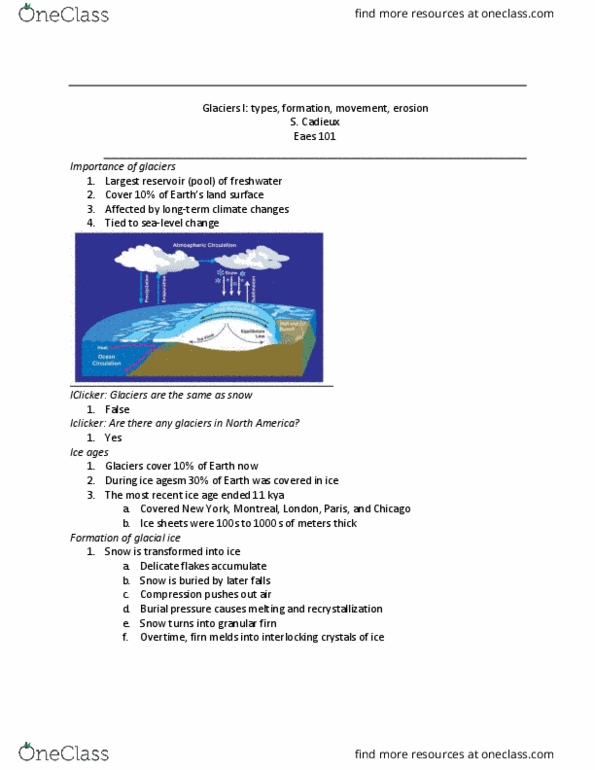
Glaciers cover approx 10% of Earth
During ice ages, coverage expands to approx 30%
-
Ice metamorphism
Delicate flakes accumulate
-
Snow buried by later falls
-
Compression expels air
-
Burial pressure causes melting and recrystallization
-
Snow turns into granular firn
-
Over time, firn melds into interlocking crystals of ice
-
Glacier: thick masses of perennial, recrystallized ice
3 conditions to form glacier
Cold local climate
○
Abundant snow
○
Snow must not be removed
○
-
Form if ice mass balance is positive
-
Depends on temp and moisture (snowfall)
-
Important for erosion, transport, and deposition of sediment
-
FLOW OF GLACIAL ICE
Brittle: uppermost 60m (cracking + crevasses from tension)
-
Plastic: lower than 60m (ductile flow)
Internal plastic (ductile) deformation
Ice crystals may stretch or rotate + may shear past one another
§
○
-
Ice flows
Downhill via gravity
○
Away from thickest part
○
-
Rates of flow vary -controlled by
Location in glacier (centre = faster)
○
Slope angle: steeper = faster
○
Basal conditions
○
-
Wet-bottom glaciers: water flows along base of glacier, basal sliding over
meltwater/sediment slurry
More temperate climates
○
Faster flow velocities
○
-
Dry-bottom glaciers: cold base frozen to substrate, movement by internal
plastic deformation of ice
Cold, dry climates
○
-
Ogives: seasonal variation of snow, acceleration at icefall
-
Glacier dynamics
Behave like a bank account
-
Zone of accumulation: area of net snow addition (snow remains in summer)
-
Zone of ablation: area of net ice loss
-
ELA lies in the middle - snow line below accumulation and above ablation
-
Examples
Swiss alps
-
Greenland
-
Tibetan plateau
-
Snow line is controlled by latitude
Temperature and insolation, precipitation
○
-
Antarctic continental ice sheet = continental glaciers
-
Nunataks: mountain peaks
-
Cirque glacier: constricted ice in upper zones
-
Glaciers are important forces of landscape change
Erosion1.
Transport2.
Deposition3.
Glacial abrasion -substrate pulverize to fine rock flour
Sand in moving ice abrades and polishes bed rock
○
Large rocks dragged across bedrock gouge striations
○
Boulders crack crescentic chatter marks into bedrock
○
-
Plucking: ice breaks off and removes bedrock fragments
-
Glacial incorporation: rocks surrounded and carried off
-
Glacier erosion
Horn
-
Cirque: ice mass at the top accumulated
-
Hanging valley
-
V-shaped valley forms
-
Glacial sediment transport
Glaciers carry a lot of SEDIMENT
-
Entrainment from erosion
Surface sediment incorporated into a fluid flow
○
-
Mass wasting onto ice from adjacent cliffs
-
When glacial ice melts -> material dropped
-
Supraglacial debris: on top1.
Subglacial debris: below glacier2.
Englacial: in glacier3.
Proglacial: in front of glacier (meltwater discharge)4.
Glacial drift: sediment deposited as a result of glacial erosion / transport
-
Glacial sediments
Erratics: glacially deposited rock resting on surface made of different
rock (far away source)
○
Till: non-sorted glacial drift deposited directly from ice
Poorly sorted
§
Erratic boulders
§
Clasts of erratic lithologies
§
Striated clasts
§
Clasts/polished surfaces
§
Glaciotectonic structures
§
○
-
Glacial moraines
Moraines: deposits of till that have form diff to underlying bedrock
Accumulation of soil and rock debris picked up advancement period
○
Ground: beneath glacier, hummocky topography
○
Medial: mid-ice moraine from merging lateral moraines
○
Lateral: along the flank of a valley glacier
○
-
End-or-Terminal
Seen where glacier stopped - at lowest end of glacier
§
○
Show location of what glacier used to look like
-
Kame (marginal) terraces: indicate retreat of glaciers
-
Proglacial landscapes + consequences of glaciation
Terminal moraines / recessional moraines
-
Drumline: oscillations in retreat - reformed, streamline land
-
Esker: long, sinuous features due to filled in subglacial melt waters - ridges
-
Outwash plain: braided rivers in front of glacier
-
Kettle holes: form b/c chunks of ice remain in landscape for longer than
glacier has needed to retreat -> melt + form depressions
-
Landscapes and sediments of large areas formed + influenced by glaciation 1.
Glacier and moraine damming, potential for out-burst floods 2.
Subsidence and rebound: lithosphere depressed into mantle followed by
rebound - continues slowly today
Isostasy (gravitational equilibrium b/w crust and mantle so crust
floats) effect on sea level - asthenosphere comes back and sea level
shrinks
-
3.
Glacier dynamics
Size change depends on balance b/w accumulation and ablation during full
season
Advances or retreats
○
-
Temp + precipitation changes
-
Global glaciations
Evidence
Fossil till + striated bedrock
○
-
Today warming trend -> glaciers recede
-
Interglacials last approx 10,000 years (but 11,000 years have already passed
since last deglaciation)
-
Glaciers and Ice Sheets
Thursday, 7 June 2018
9:36 pm

Glaciers cover approx 10% of Earth
During ice ages, coverage expands to approx 30%
-
Ice metamorphism
Delicate flakes accumulate
-
Snow buried by later falls
-
Compression expels air
-
Burial pressure causes melting and recrystallization
-
Snow turns into granular firn
-
Over time, firn melds into interlocking crystals of ice
-
Glacier: thick masses of perennial, recrystallized ice
3 conditions to form glacier
Cold local climate
○
Abundant snow
○
Snow must not be removed
○
-
Form if ice mass balance is positive
-
Depends on temp and moisture (snowfall)
-
Important for erosion, transport, and deposition of sediment
-
FLOW OF GLACIAL ICE
Brittle: uppermost 60m (cracking + crevasses from tension)
-
Plastic: lower than 60m (ductile flow)
Internal plastic (ductile) deformation
Ice crystals may stretch or rotate + may shear past one another
§
○
-
Ice flows
Downhill via gravity
○
Away from thickest part
○
-
Rates of flow vary -controlled by
Location in glacier (centre = faster)
○
Slope angle: steeper = faster
○
Basal conditions
○
-
Wet-bottom glaciers: water flows along base of glacier, basal sliding over
meltwater/sediment slurry
More temperate climates
○
Faster flow velocities
○
-
Dry-bottom glaciers: cold base frozen to substrate, movement by internal
plastic deformation of ice
Cold, dry climates
○
-
Ogives: seasonal variation of snow, acceleration at icefall
-
Glacier dynamics
Behave like a bank account
-
Zone of accumulation: area of net snow addition (snow remains in summer)
-
Zone of ablation: area of net ice loss
-
ELA lies in the middle - snow line below accumulation and above ablation
-
Examples
Swiss alps
-
Greenland
-
Tibetan plateau
-
Snow line is controlled by latitude
Temperature and insolation, precipitation
○
-
Antarctic continental ice sheet = continental glaciers
-
Nunataks: mountain peaks
-
Cirque glacier: constricted ice in upper zones
-
Glaciers are important forces of landscape change
Erosion1.
Transport2.
Deposition3.
Glacial abrasion -substrate pulverize to fine rock flour
Sand in moving ice abrades and polishes bed rock
○
Large rocks dragged across bedrock gouge striations
○
Boulders crack crescentic chatter marks into bedrock
○
-
Plucking: ice breaks off and removes bedrock fragments
-
Glacial incorporation: rocks surrounded and carried off
-
Glacier erosion
Horn
-
Cirque: ice mass at the top accumulated
-
Hanging valley
-
V-shaped valley forms
-
Glacial sediment transport
Glaciers carry a lot of SEDIMENT
-
Entrainment from erosion
Surface sediment incorporated into a fluid flow
○
-
Mass wasting onto ice from adjacent cliffs
-
When glacial ice melts -> material dropped
-
Supraglacial debris: on top1.
Subglacial debris: below glacier2.
Englacial: in glacier3.
Proglacial: in front of glacier (meltwater discharge)4.
Glacial drift: sediment deposited as a result of glacial erosion / transport
-
Glacial sediments
Erratics: glacially deposited rock resting on surface made of different
rock (far away source)
○
Till: non-sorted glacial drift deposited directly from ice
Poorly sorted
§
Erratic boulders
§
Clasts of erratic lithologies
§
Striated clasts
§
Clasts/polished surfaces
§
Glaciotectonic structures
§
○
-
Glacial moraines
Moraines: deposits of till that have form diff to underlying bedrock
Accumulation of soil and rock debris picked up advancement period
○
Ground: beneath glacier, hummocky topography
○
Medial: mid-ice moraine from merging lateral moraines
○
Lateral: along the flank of a valley glacier
○
-
End-or-Terminal
Seen where glacier stopped - at lowest end of glacier
§
○
Show location of what glacier used to look like
-
Kame (marginal) terraces: indicate retreat of glaciers
-
Proglacial landscapes + consequences of glaciation
Terminal moraines / recessional moraines
-
Drumline: oscillations in retreat - reformed, streamline land
-
Esker: long, sinuous features due to filled in subglacial melt waters - ridges
-
Outwash plain: braided rivers in front of glacier
-
Kettle holes: form b/c chunks of ice remain in landscape for longer than
glacier has needed to retreat -> melt + form depressions
-
Landscapes and sediments of large areas formed + influenced by glaciation 1.
Glacier and moraine damming, potential for out-burst floods 2.
Subsidence and rebound: lithosphere depressed into mantle followed by
rebound - continues slowly today
Isostasy (gravitational equilibrium b/w crust and mantle so crust
floats) effect on sea level - asthenosphere comes back and sea level
shrinks
-
3.
Glacier dynamics
Size change depends on balance b/w accumulation and ablation during full
season
Advances or retreats
○
-
Temp + precipitation changes
-
Global glaciations
Evidence
Fossil till + striated bedrock
○
-
Today warming trend -> glaciers recede
-
Interglacials last approx 10,000 years (but 11,000 years have already passed
since last deglaciation)
-
Glaciers and Ice Sheets
Thursday, 7 June 2018 9:36 pm
Document Summary
During ice ages, coverage expands to approx 30% Over time, firn melds into interlocking crystals of ice. Important for erosion, transport, and deposition of sediment. Brittle: uppermost 60m (cracking + crevasses from tension) Ice crystals may stretch or rotate + may shear past one another. Wet-bottom glaciers: water flows along base of glacier, basal sliding over meltwater/sediment slurry. Dry-bottom glaciers: cold base frozen to substrate, movement by internal plastic deformation of ice. Ogives: seasonal variation of snow, acceleration at icefall. Zone of accumulation: area of net snow addition (snow remains in summer) Zone of ablation: area of net ice loss. Ela lies in the middle - snow line below accumulation and above ablation. Glacial abrasion - substrate pulverize to fine rock flour. Sand in moving ice abrades and polishes bed rock. Plucking: ice breaks off and removes bedrock fragments. Glacial drift: sediment deposited as a result of glacial erosion / transport.