GEOG 2OC3 Lecture Notes - Lecture 6: Blue-Collar Worker, Canadian Shield, Redpath Sugar

26 May 2018
School
Department
Course
Professor

The Industrial Heartlands
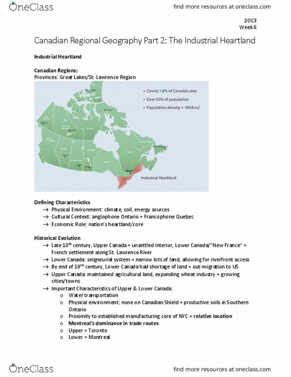
• The Great Lakes- St. Lawrence- southern Ontario and southern Quebec
• Central Canada- industrial Heartland of the country
• Heartlad: geographi area i thik a atios idustr, populatio, ad politial poer are
concentrated- core region
• .% of Caadas area
• 55% of the Canadian population
• 6 of Caadas largest esus Metropolita areas, as ell as / CMAs
• Population density is 100 people/km2- 10x higher than anywhere else
• % of Otarios populatio
• % of Quees population
• Caadas largest ities- Toronto and Montreal
3 Characteristic that define the Industrial Heartland
• Physical environment: climate, solid, and energy sources
• Culture: anglophone Ontario, francophone Quebec
• Eooi: atios heartlad
• Remarkable paradox: region historically functioned as a single economic entity
Evolution of the Industrial Heartland
• 18th century- upper Canada: largely unsettled interior of Eastern North America
• Lower Canada: New France- French settlement along the St. Lawrence River
• Upper and Lower are relative to the headwaters of the St. Lawrence River
o Lower = downriver
o Seigneurial system: long, narrow lots of land to ensure riverfront access
Upper Canada
• More favorable physical resource base than Lower Canada
• End of 19th century- virtually no shortage agricultural land, an expanding wheat economy as well
as a system of towns and cities
• Facilitated the export of wheat and the import of manufactured goods from Britain and the US
Upper and Lower
1850s
• Lower Canada had 16 towns with populations over 1000
• Largest cities were Montreal (58,000) and Quebec city (42,000)
• Upper Canada had 38 towns over 1000 people
• Largest city in Upper Canada was Toronto, 30,000
Situation and historical characteristics
• Map reveals the importance of water transportation
find more resources at oneclass.com
find more resources at oneclass.com

• Map illustrated the role of the physical environment as a determinant of settlement location- no
settlements located on the Canadian Shield
• The regios proiit to the estalished aufaturig ore of the US ad to NYC reeals the
importance of what geographers refer to as relative location or situation
• Depicts the importance of historical trade routes of staples and the development of the urban
sste, hih ere tied to Motreals doiae
• Links between the regions physical and human geographies are illustrated by the coincidence of
a large population and highly productive soils in southern Ontario
• Regions economy and the urban system are dominated by Montreal in Lower Canada, and
Toronto in Upper Canada
Industrialization: economy becomes increasingly dominated by the factory mode of production
Urbanization: society/nation is transformed from one which is predominantly rural in character to one
which is predominantly urban in character
Evolution of the Canadian Urban system
Four phases
Mercantile Phase
• Lasted until the beginning of the 19th century
• Agriculture and gaining wealth
Commercial Phase
• Started early in the 19th century
• Commercial interests and activities were primarily centered on the distribution of manufactured
goods imported from Britain and the US
The industrial phase
• Lasted from the late 19th century to about the 1960s
• 1880s saw the rise of the industrial capitalism un Canada
• During this time about 25% of the population was urban, with agriculture beginning to decline
as manufacturing was increasing in importance
The post -industrial phase
• Began in the late 20th century
• Decline of older central cities and manufacturing
• Increase in the importance of the service sector
First factor: regions access to resources- water provides energy, access to coal
Second factor the initiative or entrepreneurship of the local citizens- sir Allan MacNab
National Policy
• The eergee of a rah plat eoo i souther Otario ad Quee
find more resources at oneclass.com
find more resources at oneclass.com
Document Summary
3 characteristic that define the industrial heartland: physical environment: climate, solid, and energy sources, culture: anglophone ontario, francophone quebec, e(cid:272)o(cid:374)o(cid:373)i(cid:272): (cid:374)atio(cid:374)(cid:859)s heartla(cid:374)d, remarkable paradox: region historically functioned as a single economic entity. Evolution of the industrial heartland: 18th century- upper canada: largely unsettled interior of eastern north america, upper and lower are relative to the headwaters of the st. lawrence river. Lower canada: new france- french settlement along the st. lawrence river: lower = downriver, seigneurial system: long, narrow lots of land to ensure riverfront access. Lower canada had 16 towns with populations over 1000. Largest cities were montreal (58,000) and quebec city (42,000: upper canada had 38 towns over 1000 people. Largest city in upper canada was toronto, 30,000. Links between the regions physical and human geographies are illustrated by the coincidence of a large population and highly productive soils in southern ontario: regions economy and the urban system are dominated by montreal in lower canada, and.