EAS100 Study Guide - Final Guide: Roads In Saskatchewan, Universal Transverse Mercator Coordinate System, Contour Line

16 Apr 2016
School
Department
Course
Professor


52
EAS100 Full Course Notes
Verified Note
52 documents
Document Summary
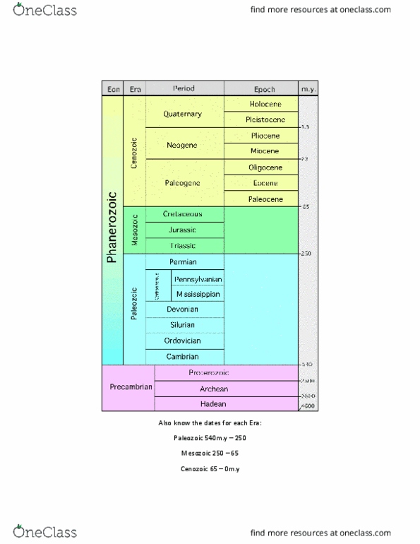
From (millions of years ago) to (millions of year ago) Hadean common sediment types and corresponding rock types. Deposited from volcanic altered to pale clay erupions sediment water. - maps are oten two-dimensional representaions of three-dimensional features. Topographic maps: show natural and ariicial features of the land surface, including topographic contours, rivers, roads, communiies etc. Geologic maps: typically shaded to show the rock-units that exist immediately below the surface. - cross-secions are interpretaions of what you would see if you could look at a slice cut through the outer parts of the. - a geologic history is a writen account of the history of an area, including all the events and processes for which there is evidence, staring with the formaion of the oldest rocks and coninuing to the present day. - equal-area projecions preserve the property of area, but distort shapes and angles between meridians and parallels. - conformal projecions preserve shape and angle, but distort area.