GEOG 2OC3 Chapter 2: Chapter 2: Canada's Physical Base


CHAPTER 2: CANADA’S PHYSICAL BASE
INTRODUCTION
● Phsial Geogaph ad phsiogaph peset a atual sste that udelie Caada’s atioal
and regional character
○ E.g. Phsial geogaph poides a fudaetal eplaatio fo Caada’s ecumene that
hugs the narrow zone just north of the border w/ the US, leaving the less hospitable
area of the country sparsely populated
● Population differences between Canada and the US can be attributed to physical geography
● Core/periphery model: regions with a more favourable physical base are more likely to develop
into core regions that contain large populations, and regions with less favourable physical
conditions have fewer opportunities to encourage settlement and economic development
Vignette 2.1 : Two Different Geographies
- Canada has a much larger geographic area, but has much smaller area suitable for agriculture
and settlement
- A significant portion of Canada lies in high latitudes with polar climates and permfrost that
place it far beyond the limits of commercial agriculture and settlement
- Most Canadians live in a narrow zone close to the border where more temperate climates
prevail
- The US has more suitable physical space for settlement, which has allowed its population to
reach 324 million
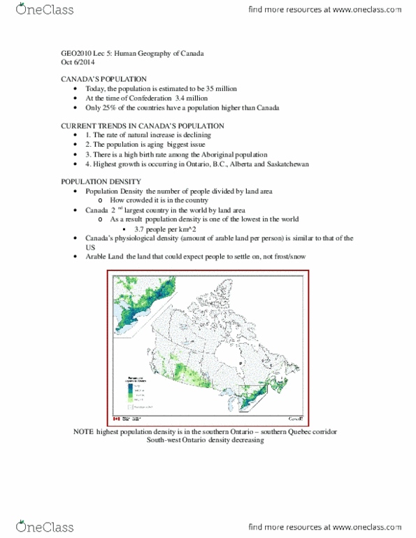
- Canada has a population of 4 people/km2 compared to 30 in the US
- Most iigats to Caada take up esidee i oe of Caada’s thee lagest ities Tooto,
Montreal, Vancouver) or in Calgary, Edmonton, Winnipeg, Saskatoon, and Regina
PHYSICAL VARIATIONS WITHIN CANADA
● Climates vary across Canada:
○ Temperate climates in south and polar in the north
○ Maritimes have mild, wet climate, and Arctic has cold, dry climate
● Climate affects the shape of landforms through weathering and erosion
● Geographers perceive a two way relationship between people and the physical world
○ Favourable physical conditions make a region more attractive for human
settlement
○ MIld climate and fertile soils in the Great Lakes-St. Lawrence Lowlands encourage
agricultural settlement and low-cost water transportation to local, American and world
markets
○ These featues hae ade it Caada’s idustial heatlad
● Physical geographers are concerned with all aspects of the physical world: landforms (or
physiography), bodies of water, climate, soils, and natural vegetation
● Regional geographers are more interest in how physical geography varies and its influences on
human settlement and vice versa.
find more resources at oneclass.com
find more resources at oneclass.com

○ E.g. rocky mountains are poor environment for agriculture but great for tourism
● Natue a daatiall hage the hua oupatio of the lad→ i.e. doughts ad floods
● Climate change is an example of relatively rapid change to our environment that is affecting
human landscape
● Generally, humans have a negative impact on the environment
○ Extensive land developments have reduced the size of natural habitats of wild animals in
the Bow Valley of the Rocky Mountains
○ Ua spal osues Caada’s est falad i the Niagaa Peisula, Fase Valle
and Okanagan Valley.
○ Humans are the most active and most dangerous agents of environmental change
Vigette .: The Eath’s Cust ad Majo Tpes of Roks
- Consists of three types of rock:
1) Igneous: Formed by molten rock known as magma 4.5bya
2) Sedimentary: formed by particles derived from previously existing rock.
- Through denudation (weathering and erosion), rocks were broken down and
transported by water, wind, or ice and deposited in a lack or sea to form a
soft substance or mud.
- The pressure form additional layers of sediments and chemical action
produces hardening.
- Sedieta oks osists of stata d/t to thei foatio i laes→ uiue
characteristic
3) Metamorphic rocks are distinguished by their origin: igneous or sedimentary under
tremendous pressures and high temperatures.
- Podued he eath’s ust folds ad faults
- Lava from volcanoes constitutes a metamorphic rock
- Basal: cooling of thick lava flow product
THE NATURE OF LANDFORMS
● Three principle types of landforms
○ Mountains
○ Plateaus
○ Lowlands
● The earth is actively shaped and reshaped but from the human perspective it is relatively stable
● The Appalachian Uplands in Atlantic Canada and Quebec are undergoing a very slow process
called denudation: the gradual wearing down of mountains by erosion and weathering over
millions of years.
○ Weathering breaks down the solid rock into smaller particles
○ Erosion transports these smaller particles by air, ice or water to lower locations where
they are deposited.
○ This sudues the daati steepess of a outai hai→ the outais i NS used to
look like the Rocky Mountains!
find more resources at oneclass.com
find more resources at oneclass.com

● Deudatio ad depositio ae ostatl at ok ad daatiall eshape the eath’s sufae
PHYSIOGRAPHIC REGIONS
● Definition: a large aea of the eath’s ust that has thee ke haateistis- 1) extends over a
large, contiguous area with similar relief fts 2) Landform shaped by a common set of geomorphic
processes 3) Possesses a common geological and structural history
● Canada has seven regions
● Canadian shield is the largest
● Great Lake- St Lawrence Lowlands (GLSLL) smallest
● Cordillera has the most spectacular and varied tophgraphy
● Hudson Bay Lowlands has the most uniform relief
● Three physiographic regions are organized in a strong north-south orientation:
○ Interior Plains
○ Cordillera
○ Appalachian Uplands
● In order from oldest to youngest physiographic regions: Canadian Shield; Appalachian Uplands
and Arctic lands; Interior Plains; Cordillera; GLSLL ; Hudson Bay Lowlands.
● Canadian Shield
○ 4.5bya
○ Much of the Canadian Shield lies under other physiographic regions
○ It is also the largest exposure of precambrian-aged rock in the world
○ Contains mineral resources such as copper, diamonds, gold, nickel, iron and uranium
● Interior Plains
○ 500mya
○ Ancient rivers deposited sediment in a shallow sea that existed in this area
○ This accumulated and included massive amounts of vegetation, as well as the remains of
dinosaurs and other creatures
○ These were eventually solidified in sedimentary rock 1-3 km thick
○ Have sedimentary structure
○ Vast oil ad gas deposits→ aleta oil sads
○ Its resources are responsible for its growing economy
● Factors that affect erosion
○ The surface material in each regio→ aies i hadess ad esistae to eosio
○ Wind, water, and ice activity
○ Gravity: has a greater erosional impact in mountainous regions that on flatter landforms
○ Permafrost: limits the activities of all erosional agents
● The Wisconsin ice sheets is the largest shaper of Canadian topography
○ They spread out from their center
○ 4 km thick
● Glacial movement is slow, acts a stiff liquid
● The Late Wisconsin advance began 30kya and represents the end of the Pleistocene epoch
○ Consisted of two major ice sheets: Laurentide and Cordilleran
find more resources at oneclass.com
find more resources at oneclass.com
Document Summary
Ph(cid:455)si(cid:272)al geog(cid:396)aph(cid:455) a(cid:374)d ph(cid:455)siog(cid:396)aph(cid:455) p(cid:396)ese(cid:374)t a (cid:374)atu(cid:396)al s(cid:455)ste(cid:373) that u(cid:374)de(cid:396)lie ca(cid:374)ada"s (cid:374)atio(cid:374)al and regional character. Ph(cid:455)si(cid:272)al geog(cid:396)aph(cid:455) p(cid:396)o(cid:448)ides a fu(cid:374)da(cid:373)e(cid:374)tal e(cid:454)pla(cid:374)atio(cid:374) fo(cid:396) ca(cid:374)ada"s ecumene that hugs the narrow zone just north of the border w/ the us, leaving the less hospitable area of the country sparsely populated. Population differences between canada and the us can be attributed to physical geography. Core/periphery model: regions with a more favourable physical base are more likely to develop into core regions that contain large populations, and regions with less favourable physical conditions have fewer opportunities to encourage settlement and economic development. Canada has a much larger geographic area, but has much smaller area suitable for agriculture and settlement. A significant portion of canada lies in high latitudes with polar climates and permfrost that place it far beyond the limits of commercial agriculture and settlement. Most canadians live in a narrow zone close to the border where more temperate climates prevail.