GEOG 1HB3 Lecture Notes - Lecture 3: Cartogram, International Date Line, Contour Line

24 Aug 2016
School
Department
Course
Professor

Thursday, September 17, 2015
Geography 1HB3 - Human Geographies: City &
Economy
Introduction to Maps
-Maps are 2-dimensional graphical representations of the world, and depict spatial
relationships
-Maps communicate information
-Maps are an analysis of spatial information
-They are ‘socially constructed’
•People control what they want to put on the map
-e.g. Population, Geographical Patterns, Statistics
•Read maps with a critical eye
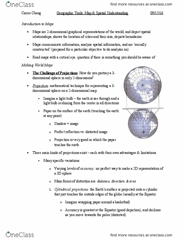
Maps: Challenges of Projections
-How do you portray a 3-D sphere in 2-D
-Projection: Mathematical technique for representing a 3-dimensional sphere on a 2-
dimensional map
•Imagine a light bulb
•Paper on the surface of the earth
-Shadow = Image
-Perfect reflection vs. distorted image
-Three main kinds of projections exist - each with their own advantages and limitations
•Many specific variations
-Varying levels of accuracy
-Main forms of distortion are
•Distance
•Direction
!1
find more resources at oneclass.com
find more resources at oneclass.com
Document Summary
Maps are 2-dimensional graphical representations of the world, and depict spatial relationships. Maps are an analysis of spatial information. They are socially constructed": people control what they want to put on the map. E. g. population, geographical patterns, statistics: read maps with a critical eye. How do you portray a 3-d sphere in 2-d. Projection: mathematical technique for representing a 3-dimensional sphere on a 2- dimensional map: imagine a light bulb, paper on the surface of the earth. Three main kinds of projections exist - each with their own advantages and limitations: many speci c variations. Main forms of distortion are: distance, direction. Azimuthal projections: the earth"s surface is projected onto a at surface that touches the globe at one point only (usually the polar regions) Latitude and longitude: a system of imaginary arcs which are used to identify an absolute location for all areas of the earth.