ENG 4339 Lecture 7: cultural-insights


Unit 1.
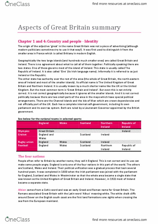
An introduction to Britain: Geographical facts & figures
GEOGRAPHICAL IDENTITIES
-The United Kingdom is also called British Isles
* isle = island, the determination of the term isle or island is set arbitrarily. For
example: Islas Canarias are known as Canarian islands not Canarian Isle’s.
- British Isles are exactly two:
oThe biggest in known as Great Britain which is its geographic name.
oThe small one is Ireland.
Those islands are located at the north-west of Europe (Northwest European
mainland.)
-Ireland, in a political level, is divided in two parts. One of those parts is
Northern Ireland, which is part of the UK and its capital city is Belfast.
-The United Kingdom of Great Britain and Northern Ireland is also known as
UK (United Kingdom).
-The most important part of the UK because of its size and economic boost, is the
South of Great Britain, known as England whose capital is London (it’s the
biggest city and has 6/7 millions of habitants). London is also one of the most
important metropolitan areas from Europe.
-The second biggest city and also very famous because of its industry
development during the Industrial Revolution is Birmingham. Due to this
revolution, small cities started to grow tremendously and develop. That’s the
reason why it gained much importance.
-In the south, we can se a small island, which is part of England, known as Isle of
Wight. It is located at the English Channel (channel which is located between
England (Great Britain) and France).
1
Distributing prohibited | Downloaded by Cfisd Center ([email protected])
lOMoARcPSD|2520155
- Wales is another part of the UK also located in Great Britain, specifically in the
southwest of England. Its capital is Cardiff.
-In the northwest of the coast of Wales, we can se a small island known as
Anglesey, this island is part of Wales.
-In the north of Great Britain, there is Scotland whose capital is Edinburgh. The
second biggest city of Scotland, and very famous because of its industrial past, is
Glasgow. All of the islands located around Scotland (Hebrides, Shetland,
Orkneys, Firth of Clyde), are part of Scotland.
-Scotland has always been divided in two parts, north and south. The north of
Scotland is mountainous and the south is plane. That’s the reason why a lot of
people live on the south and less people live in the north. Another reason why
there is more people living in the south, is due to its proximity to England.
-Once explained the 4 countries which form the UK (Northern Ireland, Scotland,
Wales and England),
-Let’s talk about the islands like the Isle of Man (also known as Mann/Manx)
or the Channel Islands, considered crown dependencies.
-The Isle of Man is a self-governing Crown Dependency of the United Kingdom,
located in the Irish Sea between the islands of Great Britain and Ireland, within
the British Isles. The head of state is Queen Elizabeth II. The island is not part of
the United Kingdom, but its foreign relations and defence are the responsibility
of the UK Government. Although the United Kingdom does not usually interfere
in the island's domestic matters, its "good government" is ultimately the
responsibility of the Crown (in practice, the Government of the United
Kingdom).
-It happens the same with Channel Islands, located in the English Channel,
which, separates England and France. They also recognize the authority of the
British Queen Elisabeth II.
2
Distributing prohibited | Downloaded by Cfisd Center ([email protected])
lOMoARcPSD|2520155

-Anyway, both are “ruled” by a Lieutenant Governor appointed by the British
government.
-Geographically speaking, it is clear that Great Britain, Ireland and all the smaller
islands belongs together. During the nineteenth and twentieth centuries, they
were called the British Isles but this name is regarded as outdated name by
people in Ireland and also Britain because it calls to mind the time when Ireland
was politically dominated by Britain. Now, we use Britain to refer to England,
Scotland, Wales and Northern Ireland.
UK TOPOGRAPHY
-As we can see in any map, the north of Great Britain is more mountainous than
the south (England), and even more than de medium zone (South of Scotland).
3
Distributing prohibited | Downloaded by Cfisd Center ([email protected])
lOMoARcPSD|2520155
Document Summary
An introduction to britain: geographical facts & figures. The united kingdom is also called british isles. * isle = island, the determination of the term isle or island is set arbitrarily. For example: islas canarias are known as canarian islands not canarian isle"s. British isles are exactly two: the biggest in known as great britain which is its geographic name, the small one is ireland. Those islands are located at the north-west of europe (northwest european mainland. ) Ireland, in a political level, is divided in two parts. Northern ireland, which is part of the uk and its capital city is belfast. The united kingdom of great britain and northern ireland is also known as. The most important part of the uk because of its size and economic boost, is the. South of great britain, known as england whose capital is london (it"s the biggest city and has 6/7 millions of habitants).